TUESDAY 3/30/2010 – ALICE SPRINGS >> AYERS ROCK
The Australian Pacific Touring bus picked us up outside the Aurora Alice Springs Hotel for our half day Uluru tour. Karl is our Luxury Coach Driver and Guide; unlike Richard, he methodically counts passengers.
Alice Springs is surrounded by an area of red sand the size of Europe. According to Karl, it’s only 2 right turns – along the rugged MacDonnell Ranges – and we’ll be to Uluru. He tells us stories about Todd and Alice, John McDouall Stuart, the Overland Telegraph Line, and the Royal Flying Doctor Service.
On his sixth attempt in 1861-1862, John McDouall Stuart, a Scottish explorer, was the first explorer to travel Australia, from South to North, the entire continent. It took six attempts. Locating water sources was a continual challenge for his team. On his fourth expedition, in April of 1860, Stuart discovered a river, which he named Finke River, in honor of William Finke, one of the primary backers of Stuart’s expeditions. Also in April 1860, he named the MacDonnell Ranges after Sir Richard Graves MacDonnell, the governor of South Australia. Ten years after Stuart’s final expedition, the Australian Overland Telegraph Line was constructed along his route. Stuart Highway, the main road from Port Augusta to Darwin, follows his route.
PASTORLES are state run cattle stations (ranches); the average size is 1,000,000 acres. There are approximately 90 cattle stations in Northern Australia. Today, ranchers use helicopters and motorbikes to round up cattle; cattle is branded and microchipped. 98% of cattle are WATER TETHERED, fenced in an area with a water trough to increase their chance of survival in 40 degree Celsius (104 F) heat. In the past, DROVERS moved cattle from the stations to market or to the countryside (primarily near Adelaide). Cattle were expected to cover approximately 18 km per day. DROVERS were replaced by ROAD TRAINS, which can transport ~180 cattle/truck.
We passed a ROAD TRAIN carrying supplies to Alice Springs.
ROAD TRAINS are semi trucks pulling multiple trailers. On Stuart Highway, road trains are limited to a maximum of 4 trailers, 53 ½ meters in length, and 86 wheels. They can weigh more than 160 tons and need more than one kilometer to stop.
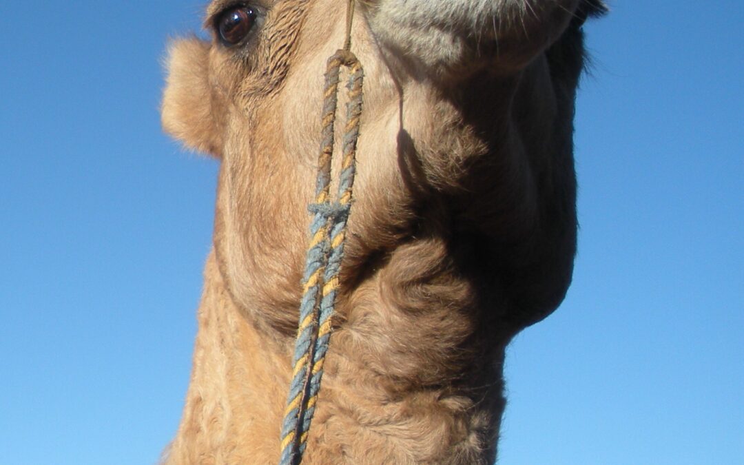
Camels were imported to Australia beginning in the 1840s to use as transportation on expeditions. They were well suited for the desert conditions since they could go for long periods without water and didn’t require (horse)shoeing. From 1860 – 1900 small groups of cameleers (referred to as “Afghans” although they came primarily from Pakistan and India) were shipped in and out of Australia at 3-year intervals to service the ranching industry. As the cameleers gained knowledge of the Australian outback, they began their own businesses, importing and running CAMEL TRAINS transporting people and goods. It’s estimated that approximately 15,000 camels were imported by 1900. The camels were used in the construction of the telegraph line and the train line. When the train line was completed in 1929, there was little use for the camels. Many of the camel drivers migrated to Adelaide; others went back to Southeast Asia. The camels (less than 100 total) were just let loose. Today there are about one million wild camels in Central Australia. Some cattle stations used to capture them and export them for additional money.
About 90 km south of Alice Springs, we stopped at Stuarts Well Roadhouse, and Lexie and I rode camels. The Camel Ride Guy was from Germany. He told us that there are no ticks in the area. Someone asked me, “Did you like the way either of those two rumps smelled?”
Back on the shuttle bus, we learned about the Hayes family that established a cattle empire in this area (including Owens Springs Station and Maryvale Station) in the 1880’s. At one point, they had 11,000 head of cattle over 13,478 square kilometers of land.
Today 2.5 square km/cow is necessary because of limited vegetation.
The Australian Overland Telegraph Line was a 3,200 km telegraph line connecting Darwin to Port Augusta. It was completed in 1872 and allowed fast communication between Australia and the rest of the world. The Western Australian section was added in 1877. In 1890, the Hayes family hauled a large consignment of steel telegraph poles to Alice Springs to replace the original wooden poles of the Overland Telegraph Line.
The Adelaide-Darwin railway follows the route of the Overland Telegraph Line. The section from Adelaide to Alice Springs was finished on August 6, 1929. The section to Darwin was completed in 2003.
According to Karl, Central Australia is a geologist’s paradise with its red sand dunes and gum trees along the Finke River.
We passed the Henbury Meteorite Craters, which were formed when meteorite fragments hit the earth’s surface in the 1970s. This is remembered by Aboriginal mythology as FIRE STAR DEVIL ROCKS (with shooting stars considered bad luck).
The Henbury Cattle Station also includes an airstrip, which is used for mail delivery and the Royal Flying Doctors, the world’s first air ambulance, which was founded in 1928, by John Flynn, MD.
Flynn was a missionary working in the Outback in the early 1900s. His work included the establishment of hospitals in bush communities. Unfortunately, that did not help those who lived far from a major community. He was appalled at the lack of medical help in remote areas.
Flynn would often recall the story of Jimmy Darcy, a stockman working on a remote cattle station, who was thrown from a horse in 1917. His friends found him with a ruptured bladder; it took them 12 hours to transport him over 30 miles to Halls Creek. The postmaster telegraphed a doctor in Perth, whom he had previously learned first aid from. The doctor, through Morse code, guided the postmaster through two bladder operations, which he performed on the Post Office table with a paring knife. Darcy died nine days later of malaria and an appendix problem before the doctor got there after travelling from Perth for ten days by boat, Model T, horse drawn carriage, and on foot. The doctor said the bladder surgeries were done well by the postmaster.
Flynn partnered with Alfred Traeger and they invented the pedal radio in the mid-1920s. The radios were gradually distributed to remote outposts enabling them to send and receive messages with a centralized medical base up to 500 km away. This new means of communication was the beginning of the end of the telegraph and an essential tool for the Royal Flying Doctor service.
Karl pointed out the Coolibah Trees, of the eucalyptus family, as we passed by. He told us this is the tree the SWAGGY sat under waiting for his BILLY to boil – a reference to the song, “Waltzing Matilda” (Australia’s best known bush ballad and unofficial national anthem.)
Karl also pointed out the Fiberoptic Booster Stations which are located every 50 km throughout Central Australia. He jokingly referred to them as Fly Catching Research Stations from New Zealand. I recall that we seriously considered buying flynets, but never did.
We left the Stuart Highway at Erldunda, a roadhouse/cattle station/gas station, and turned west onto Lasseter Highway. Almost straight east of the turnoff is Lambert Center, the geographical center of Australia.
Lasseter Highway was named after Lewis Hubert Lasseter, also known as Harold Bell, who claimed he discovered a gold reef in Central Australia decades earlier. Lasseter died in 1931 while attempting to locate the gold reef again. Nobody has since located the gold reef or been able to confirm its existence.
57 km down Lasseter Highway is Mount Ebenezer, a community in the Ebenezer Mountain Range, with 200 – 300 inhabitants. Ebenezer Flint was one of the first telegraphers. Mount Ebenezer has a small primary school with one or two teachers and health clinic with a nurse; a visiting doctor stops once a month. Students go to high school in Alice Springs or Yulara. We made a quick stop at Mt. Ebenezer Cattle Station, and Lexie pet a dingo.
We learned YULARA means “place of the howling dingo”.
The Imempa indigenous people, who operate the road house speak Lurichah language and don’t like to be photographed.
There are over 200 language groups; approximately 100 are still spoken in Australia. The Anangu languages of Pitjantjatjara and Yankunytjatjara are both spoken in Yulara.
Aborigines were semi nomadic people and the government left them alone until 1877 when Lutheran missionaries arrived from Hermansburg, Germany. The missionaries wanted to convert the Aborigines and give them an education. The Europeans brought disease, including small pox, that the Aborigines didn’t have immunities to. Besides disease, droughts forced the indigenous people closer to settlements, which ended their nomadic ways. Many liked to sleep under the stars even though they had housing. In the early 1900’s all Aboriginal children were considered wards of the state. Aborigines couldn’t vote, they couldn’t own land, they couldn’t drink alcohol, and they were not considered Australian citizens. From 1910-1970, the Australian Government took between 1/10 and 1/3 of the Aboriginal and Aboriginal/White mix children from their parents and gave them to the missionaries to provide an education. This continued until 1970 and is referred to as the Stolen Generations. Today, indigenous people only constitute about 1.5% of the Australian population.
About one third of the Northern Territory has since been returned to indigenous people. Today, they hunt emus and kangaroos with 4 wheel drives and rifles; not boomerangs.
Our next stop was the International Transit Center. About a third of the people got off of our bus and transferred to the only other bus, in the dirty parking lot, to be taken to Kings Canyon. We continued on to Yulara.
It took us 45 minutes to drive through the 1,028,000 acre Curtin Springs Cattle Station which is separated from Angus Downs by a cattle grid. We passed salt lakes filled with water due to rain. During dryer times, we would have seen big, white sand plains. This area received about 500 mm of water this year! Curtin Springs Cattle Station is the western most cattle station in Australia; it’s too dry to run cattle any further west. Beyond Curtin Springs Cattle Station, it’s aboriginal land to the west coast. Owner, Peter Severin, does weather reports for Yulara; he leaves cattle station work to his son.
Mt. Conner, “the forgotten wonder”, is a horse shoe shaped, table-topped mountain known as Attila by the aborigines; it’s three times the size of Uluru, but less known since it’s on private land of the Curtain Springs Cattle Station. Ellis Banlan, rode his motorbike over sand dunes through Mt. Conner on his way to Uluru in 1935; he died in the sand dunes 13 km past Mt. Conner because he didn’t have enough water.
Back on the bus, we saw a red car with its front smashed. Karl told us it had been disabled on side of road for a few weeks. According to Karl, Len Beadell and his team constructed the first 1,500 km road east to west across Central Australia from Alice Springs to Kalgoorlie from 1956 – 1958. You can read about it in his book, Too Long In The Bush.
The town of Ayers Rock is located in the small settlement of Yulara. It includes the Ayers Rock Resort complex which has serviced the needs of visitors to the Ulura – Kata Tjuta region since 1984. The resort includes hotels, apartments, campgrounds, supermarkets, bars, restaurants, galleries, banks, and recreational facilities.
We arrived at Ayers Rock – Voyages Desert Garden on Yulara Drive around 12:30 pm. Set among gum trees and native flowering foliage with views of Uluru. We are definitely in the outback!
Uluru (also known as Ayers Rock – as named by European settlers) is a large rock formation (approximately 2,800 feet above sea level) located in Uluru – Kata Tjuta National Park in central Australia (288 miles southwest of Alice Springs). Uluru, made of sandstone infused with minerals, changes color as the light strikes it at different times of the day and year. Oxidation has caused the rust color. The mineral, Feldspar, causes the red glow at sunrise and sunset.
Uluru is culturally significant to the Aborigines and has many storied springs, waterholes, rock caves, and ancient paintings.
After dinner, we hiked up a small hill at the resort to watch the sunset over the distant Uluru. In my opinion, the sunset was not nearly as spectacular as the one we saw in Sydney. Besides being overly giggly, Marcia & I discovered that we are horrible nighttime photographers.
Click here to refer to a GLOSSARY for words in blue.
Click here to read Australia – Day 13.
0 Comments